Upper Falls Greenway
Overview
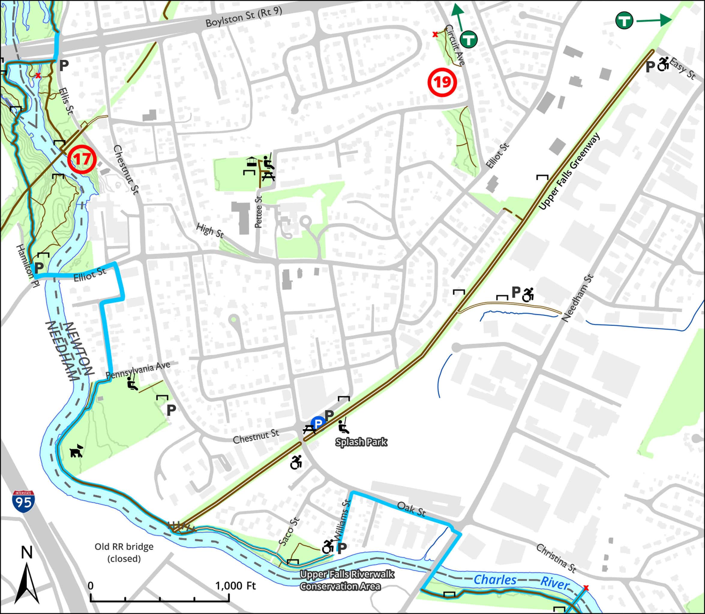
Linear park on old railroad line connecting Newton Highlands with the Charles River. Spur path runs from middle of Greenway to Needham Street.
Size: 1 mile linear park Longest Walk: 2 miles Acquired: 2013
A Highly Unofficial Route on Connections to the Upper Falls Greenway
Upper Falls Loop Trail
Maps
Locator Map and Driving Directions
Get here by MBTA:
D Riverside Green Line: a 13-minute walk from Eliot, or a less pleasant 11-minute walk from Newton Highlands
MBTA bus route 59 (infrequent service) stops at Chestnut and Oak, adjacent to the trail
Other maps and aerial photos: Bing Maps bird’s-eye view
Connects to: Blue Heron Trail
Nearby: The walk from Eliot MBTA passes by the Frank Barney and Martin Conservation Areas
Owner & Administrator Websites
Photo Gallery


First three photos shown here. Click a photo to view the complete slideshow or click here to browse the complete gallery.
History
1852
Newton Upper Falls station (now Little Luke’s Cafe) was built.
1958
Boston & Albany railroad abandoned service on Highland Branch. MBTA created D line to Riverside. Proposal to create service on branch of line from Newton Highlands to Needham was not implemented. Freight service on Upper Falls branch continued through at least 1984.
2011
Initial proposal to create greenway (more)
2013
Work begins to convert train tracks to greenway
2014
Trail originally scheduled to open. (Construction delayed.)
2015
City of Newton picks up work to complete the Greenway
2016
2020
February 20 – The MassWorks Infrastructure Grant Program awards a $396,500 grant to the City of Newton for design and engineering work that will jumpstart an extension of the Upper Falls Greenway Trail (to allow pedestrians and cyclists better access to the MBTA and Needham Street) and support improvements to safety, conditions, sustainability and vitality in the Pettee Square commercial district.
2022
At western end of Greenway, connections made to Upper Falls Riverwalk and to trail leading to Bobby Braceland Playground. (more info)
2023
Planning begins for the Newton/Needham Community Way, to extend the Greenway into Needham.
Features
Biking: Good, Blue Heron Trail, Dogs On Leash, Generally Accessible Trail, Historic Site, MBTA Green Line, Picnic Tables, Playground, Scenic View, Winter Sports
Additional Information
Advocates & Caretakers:

Upper Falls Greenway on Facebook
Related Information:
Poster of invasive plants found in the Upper Fall Greenway
The proposed Needham Rail Trail would connect to the Upper Falls Greenway.
The proposed Bay Colony Rail Trail would continue through Dover to Medfield.
Iron Horse Preservation Society began the work to convert the railbed to a greenway.
History of train service in Newton Upper Falls
A video of a ride on the trail in January 2016
2017 Environmentalist of the Year Award to the creators of the Greenway
Newsletter articles about the Greenway:
Fall 2018 (Beyond Boundaries sculpture show)
The Greenway may someday connect to the Blue Heron Trail
Report a Problem
Report a Problem in a Newton City Park