Saw Mill Brook and Kesseler Woods Conservation Areas
Overview
This site consists of three adjacent conservation areas: Saw Mill Brook, Kesseler Woods, and Baldpate Meadow.
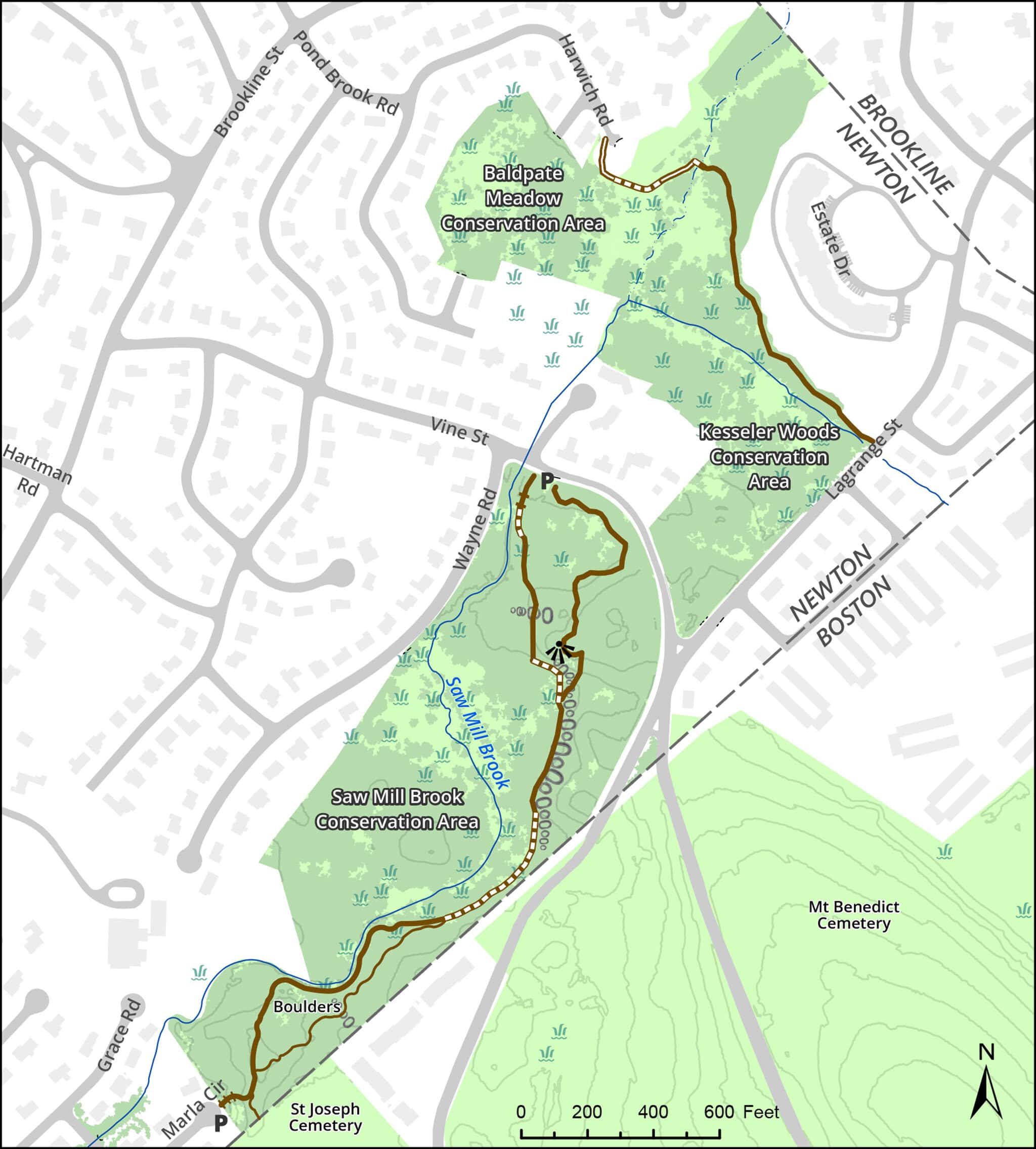
The Saw Mill Brook trail follows the brook through wooded upland and wetland and by old stone fences and dramatic puddingstone outcroppings. Baldpate Meadow, which is mostly wetlands, has no trails.
One of the last large, privately owned pieces of open space in Newton, Kesseler Woods was threatened with development in 2003. At the urging of the Newton Conservators and other open space advocates, the City of Newton was successful in protecting a majority of this property through an innovative partnership with a private developer, Cornerstone Corporation.
The city paid about one third of the $15 million purchase price, using city and state Community Preservation Act funds, with the developer paying the rest. About two thirds of the land is permanently protected as open space, and the developer also agreed to include 12 affordable homes among the apartments it built.
By connecting the existing 20-acre Saw Mill Brook Conservation Area with the 5-acre Baldpate Meadow Conservation Area, the city created a 57-acre swath of green. In addition to recreational opportunities, this area will preserve much-needed wildlife habitat, enhance groundwater recharge, and provide other environmental benefits. A trail in Kesseler was opened in 2025.
The area connects to a much larger green corridor running through West Roxbury and South Newton. Near the Marla Circle end of the Saw Mill trail, you can walk into St. Joseph Cemetery and from there, cross Baker Street to Brook Farm Historic Site. Beyond Brook Farm is the Blue Heron Trail along the Charles. More about the long walk
Size: 57 acres Longest Walk: 0.8 miles Acquired: 1979 to 1985, and 2004
Maps
Locator Map and Driving Directions
Trail Map
Click map for larger image •
Owner & Administrator Websites
Conservation Commission: Kesseler Woods
Conservation Commission: Baldpate Meadow
Photo Gallery


First three photos shown here. Click a photo to view the complete slideshow or click here to browse the complete gallery.
History
1964
Boston Edison acquires Kesseler Woods from Rosa C. Eichorn Kesseler for possible future utility use.
1979
City acquired northwest parcel of Saw Mill Brook Conservation area using state self-help funds.
1982
City acquired southern parcel of Saw Mill Brook from Temple Beth Avodah and from Benjamin Kaplan, using self-help funds.
1985
City acquired middle parcel of Saw Mill Brook by eminent domain, using state self-help funds.
2002
Massachusetts Attorney General orders Boston Edison’s successor, NStar, to dispose of surplus land holdings.
2003
NStar announces Kesseler Woods will be sold, and files preliminary subdivision plan for 68 single-family houses on large lots.
2003
City of Newton determines that city cannot afford to buy entire 42-acre property, even with CPA funds. City enters into successful joint bid with Cornerstone Development. City of Newton receives a conservation restriction on about 30 acres, including 9-acre West Kesseler Woods alongside Saw Mill Brook. The larger Kesseler Woods parcel lies across Vine Street.
2004
Purchase is completed. Cornerstone begins work on single-family houses near Brookline Street.
2005
Planning continues for construction of multi-family housing, including affordable units, off LaGrange Street.
2016
Construction begins on the multi-family housing, called Hancock Estates.
2025
Trail completed from Lagrange Street to Harwich Road.
Features
Biking: Prohibited, Conservation Area, Dogs On Leash, Geologic Features, Other Long Route, River/Lake/Pond, Scenic View
Additional Information
Newton Assessor’s Map ID: 82041 0023, 82037 0003, and other parcels
Report a Problem
Report a Problem in a Newton Conservation Area