Cochituate and Sudbury Aqueducts
Overview
You can walk a 7 mile circuit within Newton on both aqueducts. Or, you can take a 5 mile walk (returning by MBTA) from Waban to Chestnut Hill that begins on the Cochituate Aqueduct.
Cochituate Aqueduct
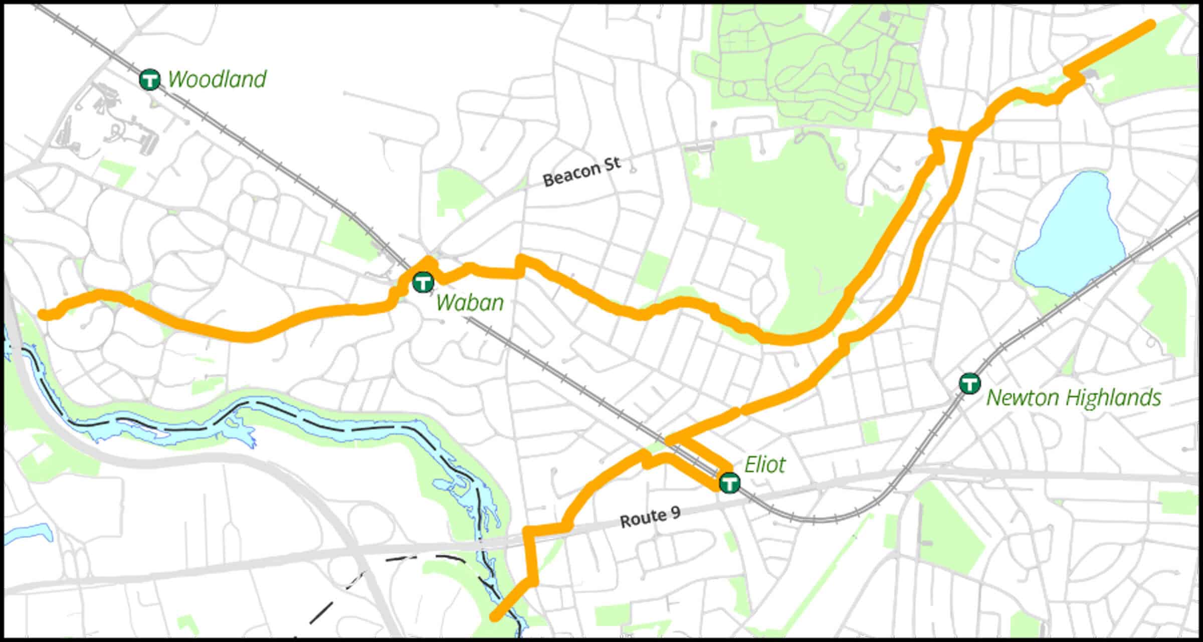
Enters Quinobequin Road area in Waban at the foot of Varick Road, after crossing the Charles River from Wellesley over a low stone bridge. When the aqueduct was in active use, the water was pumped uphill at this point. The public path runs through Waban, Cold Spring Park, Newton Highlands, the Wilson Conservation Lands, and Newton Centre Playground before it disappears in a tunnel through Waban Hill. Woodlands, pine forest, meadows.
Sudbury Aqueduct
Enters Newton Upper Falls over Echo Bridge across the Charles River in Hemlock Gorge Reservation. Nearly joins Cochituate Aqueduct near Cold Spring Park, and disappears into a tunnel at Gray Cliff Road in Newton Centre.
Longest Walk: 7 mile circuit
Maps
Locator Map and Driving Directions
The two aqueducts pass near three stations on the MBTA Green Line: a 0.5 mile walk from Newton Centre Station, or a 0.1 mile walk from Eliot Station, or a 0.2 mile walk from Waban Station
Detailed map
A detailed 18×24 map showing the routes of both aqueduct trails is included in the 2026 edition of the Conservators Trail Guide. Additional copies of the map area available for purchase. Follow this link to see the map on your computer.
Connects to:
Trail Map
Click map for larger image •
Owner & Administrator Websites
Photo Gallery


First three photos shown here. Click a photo to view the complete slideshow or click here to browse the complete gallery.
History
Cochituate
1846-1848
Built to bring water to Boston’s Chestnut Hill Reservoir from Lake Cochituate.
1952
City of Newton purchased aqueduct for sewer lines.
Sudbury
1867-1876
Built to bring water to Boston from the Sudbury Reservoir.
1978
Completion of Dorchester Tunnel allowed use of Sudbury Aqueduct to be discontinued. Aqueduct maintained by MWRA as backup source of water.
2012
 MWRA opens aqueduct rights-of-way for public trail use
Features
Aqueduct Trail, Biking: Good, Dogs On Leash, Generally Accessible Trail, Historic Site, MBTA Green Line, Other Long Route, Playground, Winter Sports
Additional Information
Newton Assessor’s Map ID: [many separate parcels]
Descriptions:
Exploring Newton’s Historic Aqueducts
Why We Care About Newton’s Aqueducts
Public Use:
Petition for public use of Sudbury Aqueduct
History:
Cochituate Aqueduct (Wikipedia)
Sudbury Aqueduct (Wikipedia)
Photos, Videos, and Art:
Photographs of Cochituate Aqueduct
Report a Problem
Report a Problem in a Park or Conservation Area