Leo J. Martin Golf Course and Riverside Park
Overview
Situated on the banks of the Charles River, the Leo J. Martin Golf Course began play in the 1930’s.
During the winter months, the course is transformed into a commercially run cross-country ski area, with equipment rental and refreshments.
Riverside Park is at the end of Recreation Road, across I-95 from the golf course.
Size: 186 acres (18 holes) Longest Walk: 0.3 miles in Riverside Park; 3 to 4 mile walks on rough trails Acquired: 1914
Maps
Locator Map and Driving Directions
Trail Map
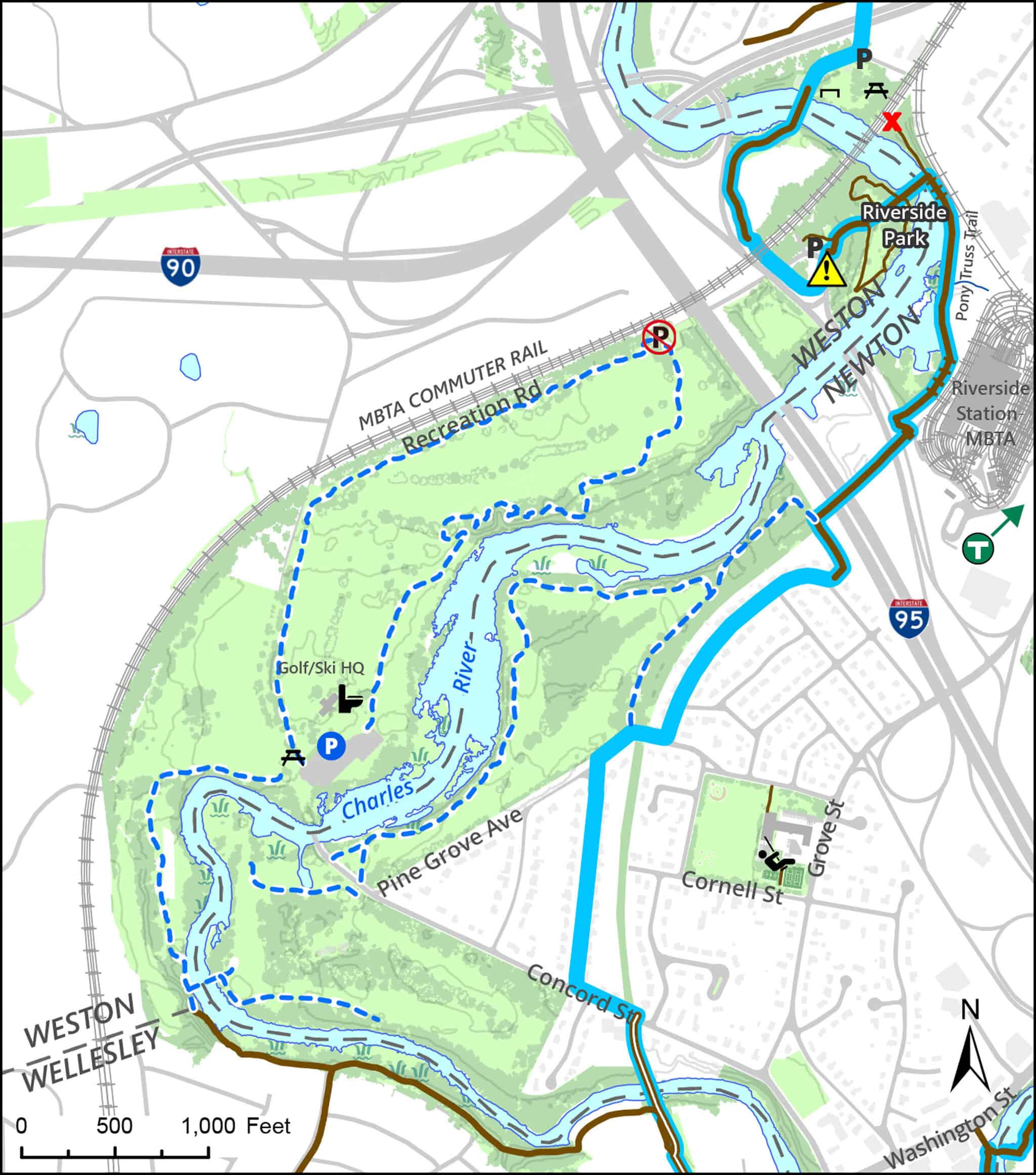
Click map for larger image •
Owner & Administrator Websites
Photo Gallery


First three photos shown here. Click a photo to view the complete slideshow or click here to browse the complete gallery.
History
Early 1900s
Riverside Recreation Grounds developed by Charles Wells Hubbard. Known as “The Rec,” it included 40 acres of riverfront with sports fields, a swimming pool, tennis courts, and a boathouse.
1914
Hubbard gave The Rec to the Metropolitan Park Commission, the predecessor to DCR.
1930
The golf course, designed by noted course architect Donald Ross, opened for play.
1958-59
The Rec closed, and the buildings burned.
2013
Rebuilt Pony Truss pedestrian bridge opened in Riverside Park
2020
Pony Truss Trail reconstructed along the Newton side of the Charles DCR proposed construction of a trail system along the edge of the golf course
Features
Biking: Prohibited, Blue Heron Trail, Dogs On Leash, MBTA Green Line, River/Lake/Pond, Toilet Facilities, Winter Sports
Additional Information
Newton Assessor’s Map ID: 42026 0003 and other parcels in Newton and Weston
Skiing:
State poised to take over Weston Ski Track (Boston Globe, 9/24/15)
Friends of Leo J. Martin Skiing
![]()
Golf:
Leo J. Martin Memorial Golf Course offers a snack bar, pro shop, and instructional services.
![]()
Trail and Development Proposals:
Proposals to restore bridges and build trails along the Charles
Newsletter articles about these proposed trails
Reconstruction of a pedestrian bridge over the Charles in Newton Lower Falls
Proposed development of the Riverside MBTA Station
Improvements to pedestrian bridges and trails in Riverside Park
Report a Problem
Report a Problem on DCR Land